The Future of Transportation across Washington takes shape in the Snoqualmie Valley
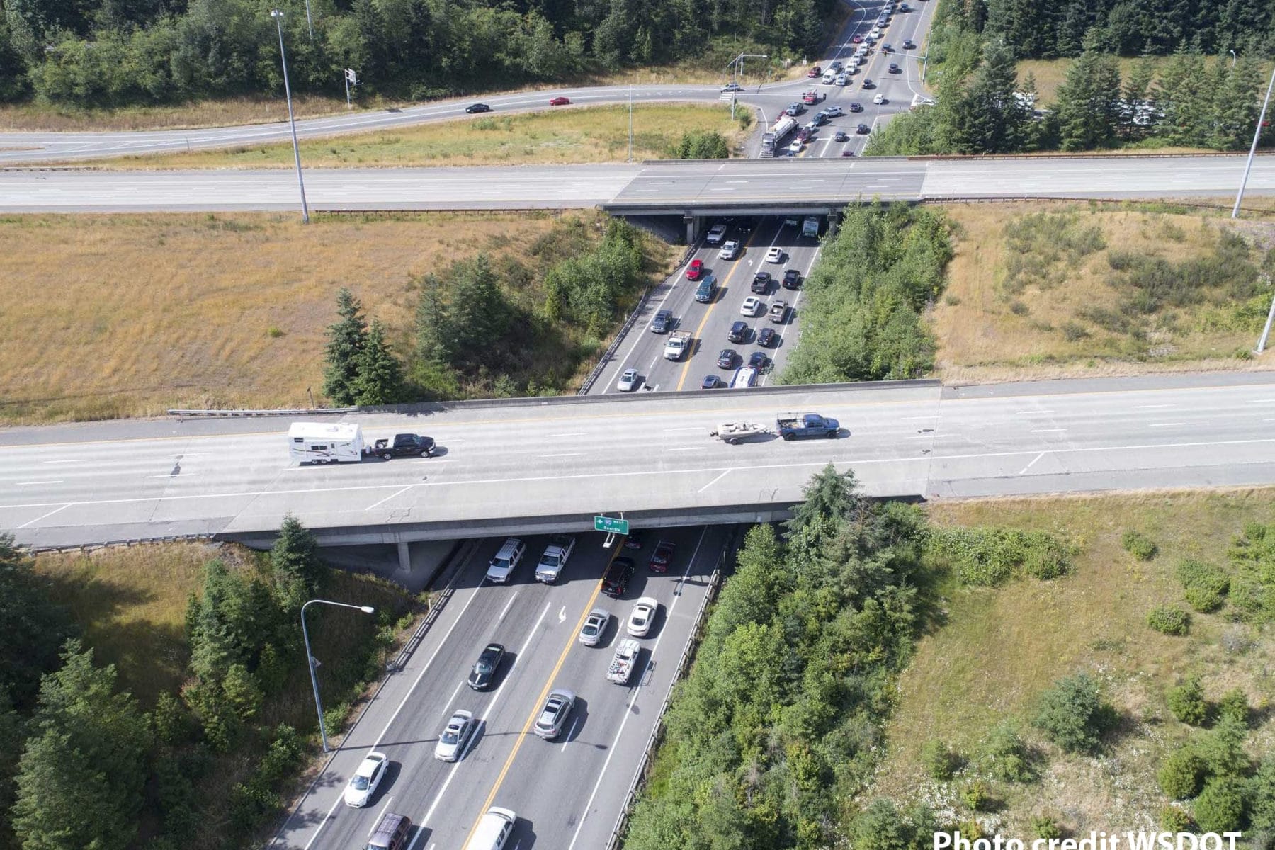
Rapid growth and development in the Snoqualmie Valley and Puget Sound region have made the Interstate 90/State Route 18 interchange one of the busiest in the state. This interchange serves people who live and work in the area, as well as freight haulers and cross-state travelers. At busy times traffic jams stretch for miles.
Thanks to the Washington State Department of Transportation (WDSDOT), the I-90/SR 18 Interchange and Weigh/Inspection Station improvements project will improve traffic flow through the interchange, decrease congestion and reduce the number of collisions.
The project includes rebuilding the interchange with a diverging diamond interchange to improve safety and traffic flow, widening SR 18 from Deep Creek to the interchange to reduce environmental impacts and improve traffic speed and safety, and building a new weigh station east of the interchange to serve eastbound truck traffic on I-90. The State Legislature has allocated $150 million in funding for this project.
WSDOT has already identified preferred alternatives for improving the interchange and for widening SR 18. WSDOT is still considering three options for the new weigh station location: at milepost 33.5 near North Bend, at milepost 45.5 near Bandera Mountain, and at milepost 80.3 near Cle Elum.
WSDOT is seeking public comments through April 30, 2019: https://i90sr18openhouse.com/.
The Greenway Trust and many of our partners have invested significant resources and more than two decades’ of advocacy to preserve the forested character of this rural interchange, just south of the city of Snoqualmie. Instead of mini malls and gas stations, we have a forested gateway to the Cascades.
As WSDOT prepares to make critically important improvements for public safety and mobility, the Greenway Trust will encourage projects to be completed in a way that protects the scenic character of the Mountains to Sound Greenway National Scenic Byway, improves regional trail connections through the interchanges and along SR 18, and balances the needs and interests of both trucks and local communities that are served by this vital infrastructure.
I-90/SR 18 Interchange
The planned diverging diamond interchange will help preserve the scenic character of the I-90/SR 18 interchange by eliminating the need for costly new flyovers or bridges. Dedicated shared use paths and crossings will help pedestrians and bicyclists move safely through the interchange and connect with planned regional trails to Maple Valley along SR 18, to Snoqualmie Ridge along the Parkway, and to Preston along an extension of the Mountains to Sound Greenway Trail.
The Greenway will continue to advocate for preserving scenic character and ensuring safe regional trail connections as planning for the interchange moves into its next phase.
SR 18 widening
This project will widen SR 18 from two lanes to four lanes with a dividing barrier from Deep Creek to the interchange. This is a vital first step toward improving safety and increasing vehicle capacity along the entirety of this busy state highway. It should be done in a way that preserves opportunities for regional trail development, and protects wildlife crossings along the river and through the forest.
SR 18 crosses the Raging River and Deep Creek and passes through the Raging River State Forest. These natural habitats are important for wildlife that regularly crosses the highway corridor when moving between Tiger Mountain and Rattlesnake Mountain. The Greenway Trust encourages WSDOT to ensure that the planned SR 18 widening, as well as any future widening projects include safe passage for wildlife at river crossings and in key wildlife corridors. Interstate 90 at Snoqualmie Pass has excellent examples of under- and over-crossings for wildlife that aid animal migrations and reduce the risk of collisions.
The SR 18 corridor also presents outstanding opportunities for expanding the regional trail network with connections between Snoqualmie and Maple Valley, and with access to the East Tiger and Raging River trail systems. Any new highway bridges needed along SR 18, including over the Raging River and Deep Creek, should be built wide enough to accommodate a future regional trail.
Weigh Station Relocation
The Washington State Department of Transportation and Washington State Patrol require an eastbound weigh station for trucks located east of the I-90/SR 18 interchange. At the same time, there is a regional shortage of truck stop facilities, while truck drivers are required to take rest stops and often need to comply with specific delivery time slots. As a result, trucks park along ramps and along the highway, creating safety hazards and impacting residents of nearby communities like North Bend. Depending on where and how this weigh station is constructed, it could help address or exacerbate the outstanding problem of where trucks can safely stop.
The Greenway Trust thinks that the new weigh station could be an opportunity if its location and design were part of a larger regional solution to managing truck mobility, public safety and capacity. We would propose that the Washington State Legislature, WSDOT, State Patrol, Ports of Seattle and Tacoma, King County and major municipalities, trucking associations and major employers, join together to come up with resources and a solution that works for the entire state. Deciding the location of a new weigh station alone is too rushed and does not take into account the context of the growth of truck volume through the region, new technologies for vehicles, or impacts to communities near each of the proposed locations.
If a weigh station location decision remains as part of this current set of projects, the Greenway Trust will advocate for mitigation measures that minimize adverse impacts and maximize benefits to nearby communities and the Scenic Byway. Following are some of the mitigation measures that the Greenway Trust thinks are necessary for each of the three locations currently under consideration:
Cle Elum:
The proposed location at milepost 80.3 is opposite from an existing weigh station on westbound I-90. We encourage the Washington State Department of Transportation and State Patrol to seriously consider this location. Its proximity to existing weigh station facilities should streamline operations, and while it is near the communities of Cle Elum and Roslyn, the exact location is far enough from their population centers to minimize impacts to local residents from noise and pollution. We encourage WSDOT to work closely with elected officials and community members in Kittitas County to fully explore this potential weigh station location.
North Bend:
The proposed location at milepost 33.5 is on the south side of I-90 adjacent to exit 34. This location presently experiences significant amounts of truck traffic associated with the truck town north of the interstate (the only commercial truck stop in the region); trucks also frequently park along the off ramps and on ramps.
North Bend residents, business representatives and councilmembers have understandably stated that their community should not need to deal with truck capacity alone, and this should be a statewide issue.
If this new weigh station infrastructure is located in North Bend, there are some critical additions to this project which could help mitigate impacts and make improvements in this small city:
- Plant a significant conifer tree buffer on both sides of Interstate 90 between exits 32 and 34, to screen both the new weigh station and the current truck town, in keeping with the natural character of the National Scenic Byway and North Bend’s goals of serving as the recreation gateway to the Cascades.
- Implement the boulevard design planned for 468th, making this currently unattractive stretch of street that serves both large trucks and small cars into a fitting gateway to nearby mountains and recreation areas, especially as the gateway to the Middle Fork Snoqualmie River Valley.
- Create the greenest, best-designed, most attractive truck stop in the country, well-screened by significant conifer trees, which would include: required electrification of trucks parked at the truck town to reduce emissions for the local community; improvements to truck movement to keep trucks at truck town and out of downtown North Bend; significant new revenue from truck parking to the City of North Bend through additional nearby services and businesses or other fee structure, potentially a locally-collected gas tax addition or fee per truck.
- Design the best possible protection for Camp Waskowitz just to the south, which might include using advanced technologies for lighting, as well as road and traffic flow improvements.
Bandera:
The third potential location for a weigh station is at Bandera at milepost 45.5 along the South Fork Snoqualmie River in the Mt. Baker-Snoqualmie National Forest. The Greenway Trust does not think this is a viable alternative. Placing new infrastructure in a national forest, along a free-flowing river, with potential impacts to nearby recreation areas and to the character of a National Scenic Byway will require the most new infrastructure and extensive mitigation. Furthermore, locating a weigh station at a distance from any population center means that there would be little to no opportunity for additional services for truck drivers or potential economic benefits to nearby towns as might be possible for the North Bend and Cle Elum locations.
Make your voice heard
We very much appreciate the Washington State Department of Transportation tackling these complicated and important infrastructure projects that are of vital importance to our region and the state of Washington.
Share your comments by April 30, 2019 at https://i90sr18openhouse.com/.